
Brief report from the front, January 25, 2025
The enemy cannot contain the advance of the Russian Armed Forces even with the involvement of reserves. Report by Marat Khairullin with illustrations by Mikhail Popov.

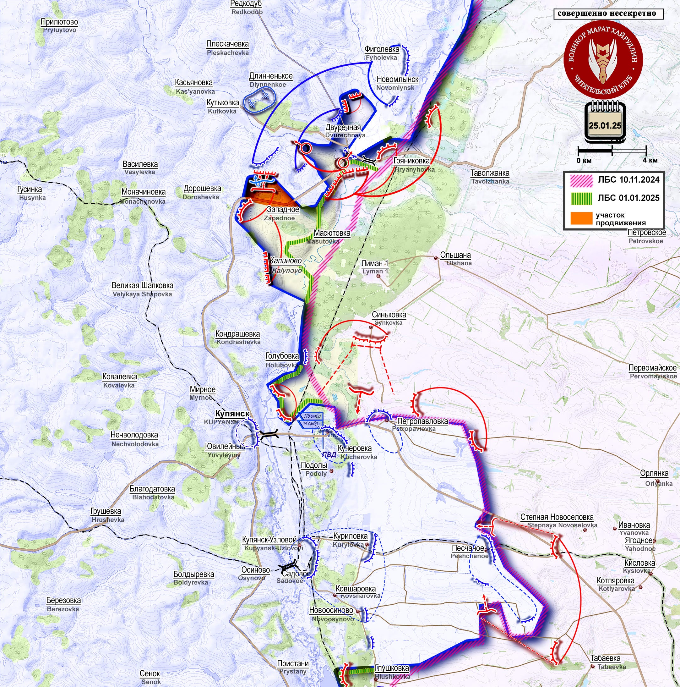
Russian troops continue to expand the territory of the bridgehead on the right bank of the Oskol River. After the liberation of the settlement of Zapadnoe, assault detachments of the Russian Armed Forces began to advance in the direction of the settlement of Kutkovka, having secured a position north of the P79 highway, which runs from the settlement of Dvurechnaya (Dvorichna) to Kupyansk and further to Borovaya (Borova) and Izyum. There are reports that movement is also going in the direction of the settlement of Doroshovka. Our military is advancing despite stubborn resistance from the enemy, who has transferred reserves from the Sumy region to the area.
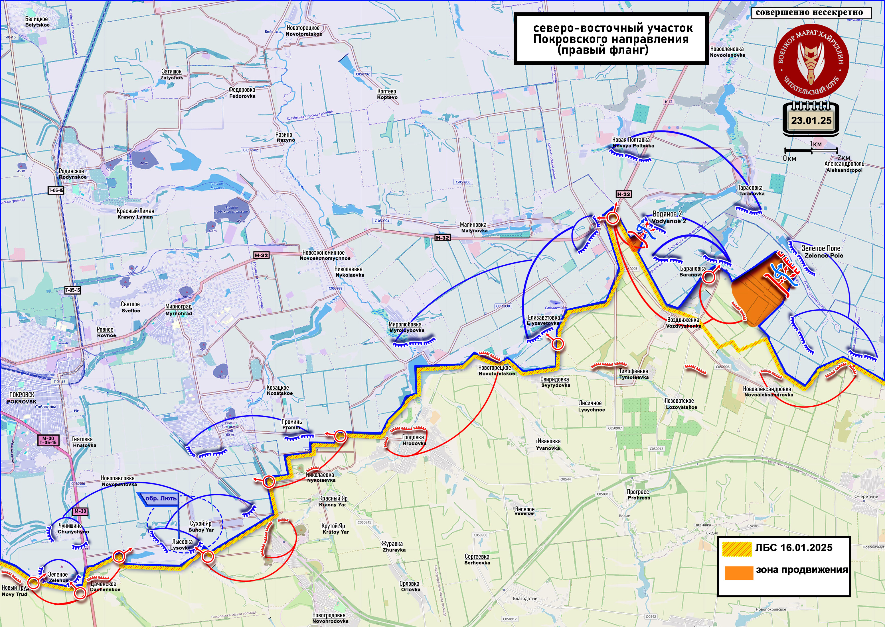
In the Pokrovsk area, units of the Russian Armed Forces are attempting to gain a foothold in the area of road N32 (Pokrovsk-Konstantinovka) east of the interchange. In order to delay the advance from our side, the enemy blew up the overpass, thus creating rubble. On the other hand, this indicates that he could no longer use it as a protected position due to the proximity of combat clashes.
On the left flank of the Pokrovsk area, after securing the territory of the agricultural farm and ventilation shaft in the area of the settlement of Kotlino (Kotlyne), the fighters of our units began to probe the enemy's defense, conducting attacks not only in the direction of the Pokrovskaya mine, but also in the direction of the E 50 highway (Pavlograd-Pokrovsk, colored in Pink).
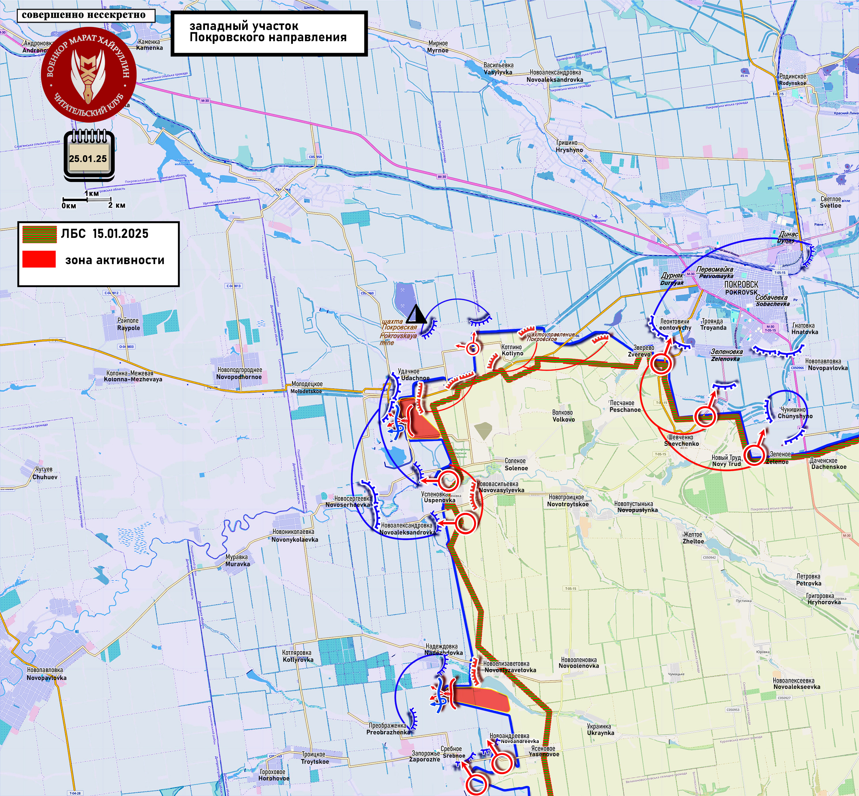
In the settlement of Udachnoe, the enemy is gradually being pushed through the territory of the settlement from the east. At the same time, our forces are trying to bypass it, expanding the control zone south of the road in order to exert pressure on the enemy in Udachnoe on the largest possible area, stretching out its forces.
In the Novoandreevka area (the southern part of which was already under our control), assault troops advanced along the ravine north of it and, putting pressure on the enemy from two sides simultaneously, drove them out of the settlement. Active clashes are taking place in the vicinity of the neighboring settlement of Srebnoe (Sribne). West of Petropavlovka, our units continue to move towards the Pokrovsk-Andreevka road, attacking the enemy dug in at their strong points.
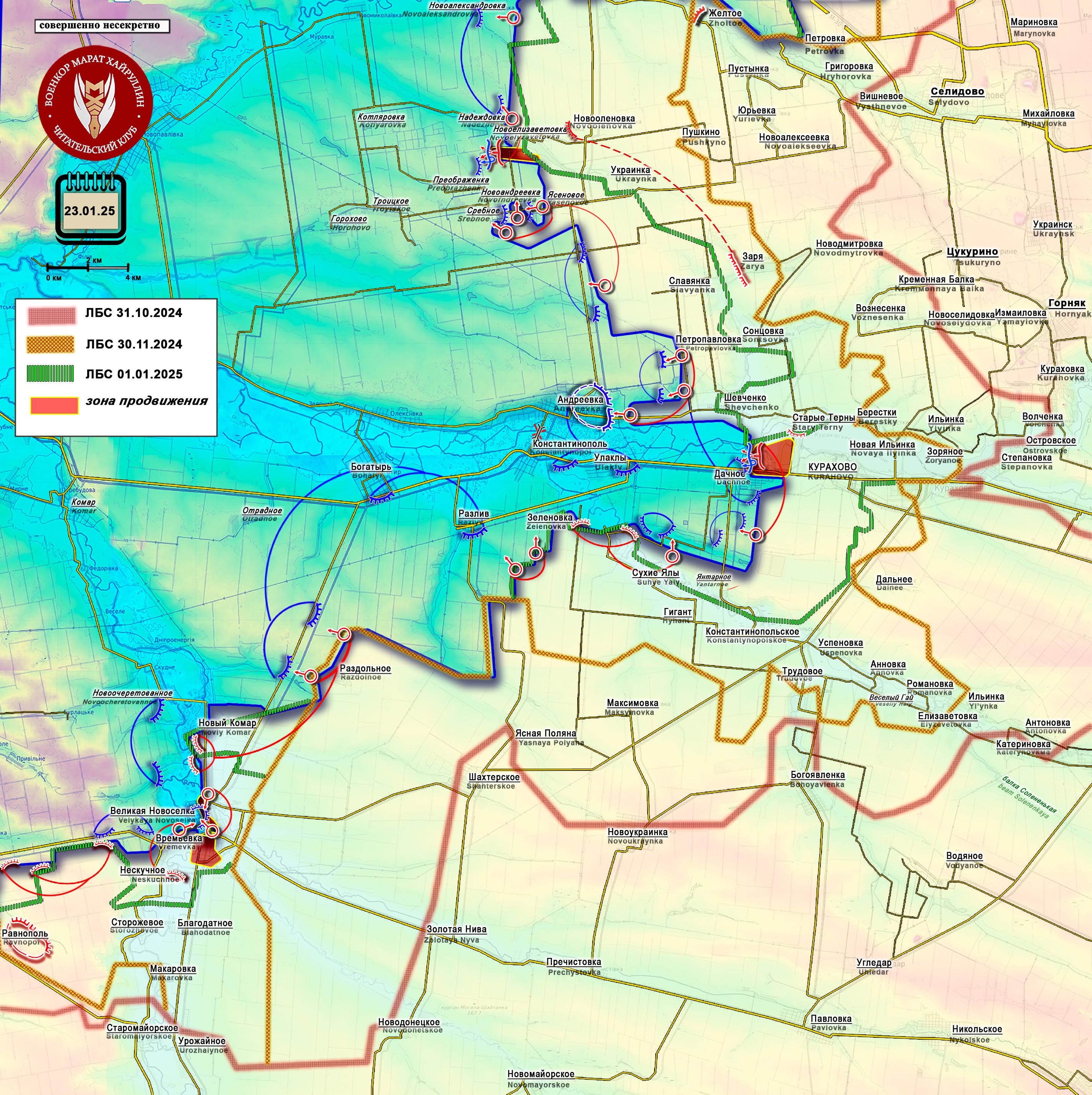
The Kurakhovsky pocket continues to shrink. Our armed forces have entered the settlement of Dachnoe and are advancing in its northern part. At the same time, the Ukrainian Armed Forces are under strong pressure from the east and southeast. The enemy is being pushed back further and further in the southern part of the pocket (north of the settlement of Sukhie Yaly), where our forces have already consolidated their positions along the ravine that runs west of the settling ponds. The enemy has a strip of land in the fields that is open to fire from our side.
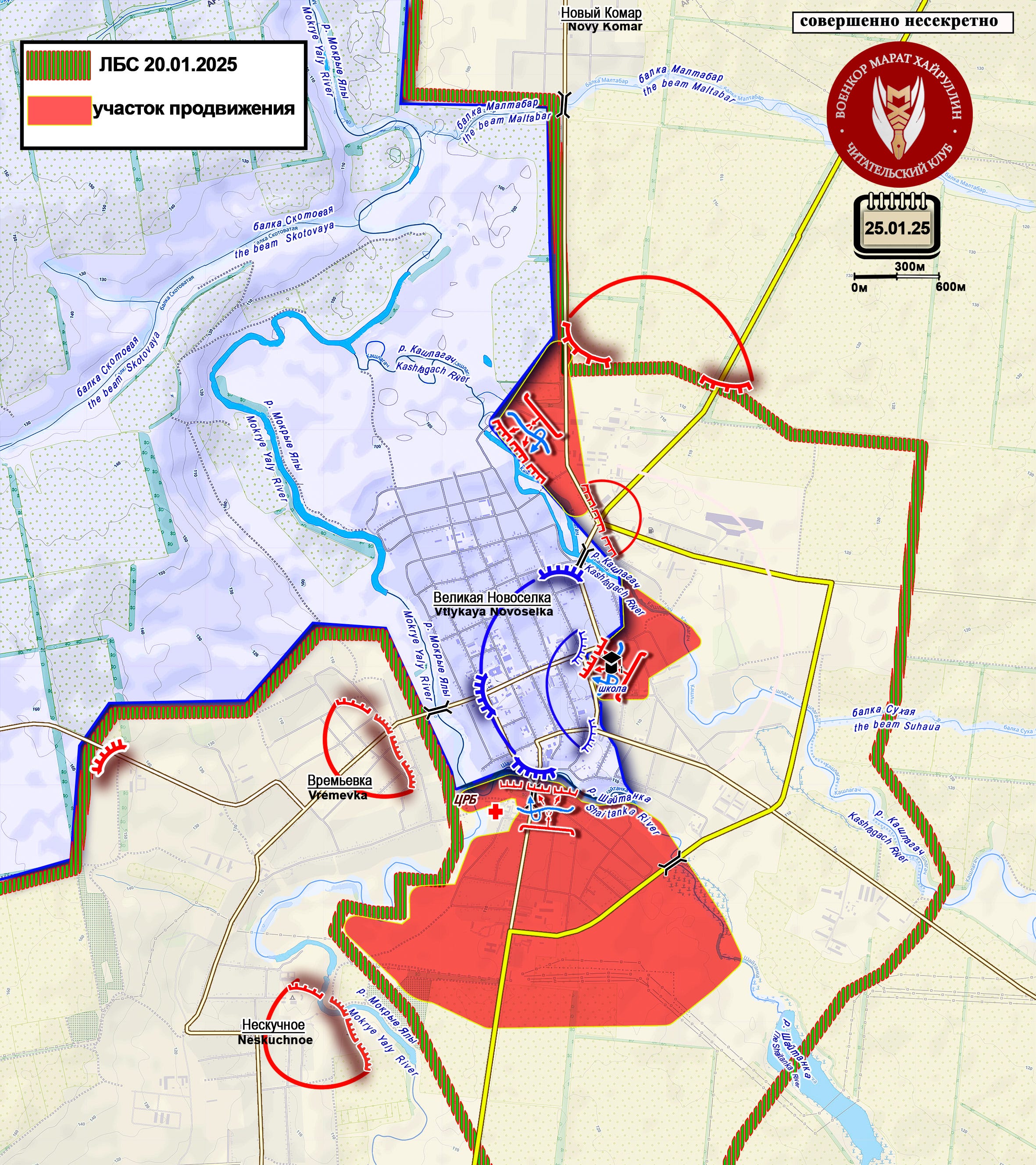
In Velikaya Novosyolka (Velikaya Novosyolka), its southern part came under the control of our units. The fighters installed a flag in the hospital area not far from the bridge (or rather the crossing over its remains). In the central part of the village, the area around the school and stadium has been cleared of the enemy. The fighting has shifted to the Mokrye Yaly River and to the northwest of the settlement. At the same time, the enemy was driven completely out of the area of Velikaya Novosyolka north of the Kashlagach River.
Translation Note: When Russian is written by hand, the "г" (when typed) looks like a backwards "S," and the "и" looks like our "u." Also, the typed Russian "т" looks like a western "m" when it is written by hand. Lastly, the "д" turns into something that looks like a "d" in Russian script as well.
If you have trouble viewing the maps on Substack then you can try our other resources:
Thanks for that. I enjoy transferring your information to my own map. Where I track the course of the conflict. I wonder about Kursk. We never get much information from there. Many times southfront and suriyakmaps on TG will report on all area except Kursk. And I see today you have nothing. But I also see that fierce fighting goes on around Malaya Loknya - 60km away from Sumy.
And I wonder how can Kiev possibly get the equipment and supplies up the R200 and then the 38k-024 in sufficient quantities to maintain their garrisons up there never mind mount attacks? But they do. They mount counter attacks and are often successful. The positions up there change hands a lot. What is the problem up there that we can't interdict their convoys even with air superiority, ecm superiority, drone superiority etc. etc... It is after all a salient, too. Do you have enough information to be able to comment on it?