


Brief Frontline Report – June 4th, 2025
Report by Marat Khairullin with illustrations by Mikhail Popov.

Sumy "Buffer" Zone
From a report by the Russian Ministry of Defense: As a result of decisive operations, units of the "North" Group have completed the liberation of the settlement of Kondratovka in Sumy Oblast.
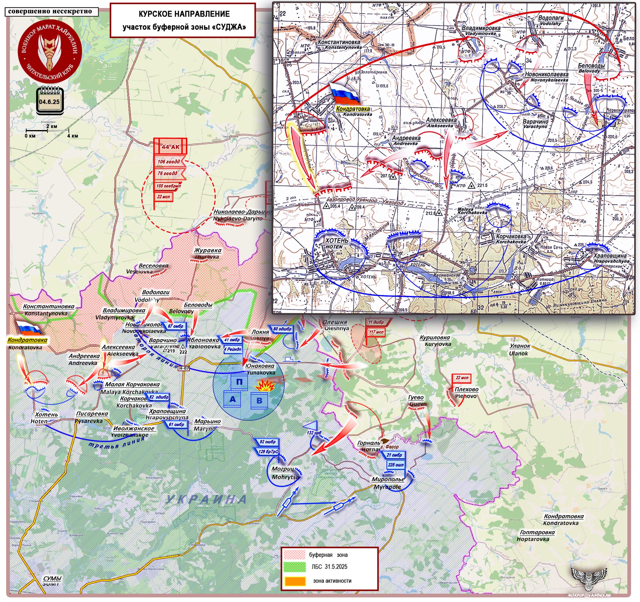
The formation of a buffer zone in the Sumy direction continues. Building on yesterday’s success following the liberation of the settlement of Andreevka, Russian Armed Forces units on the right flank have completed clearing the Konstantinovka-Kondratovka area. It appears that efforts are underway to strengthen and develop our right flank ahead of the main objective—the liberation of Yunakovka.
At the center of this zone lies a well-developed and heavily fortified Armed Forces of Ukraine (AFU) defensive area: Novonikolaevka-Varachino-Yablonovka (Chervonoprapornoe). (For some reason, Yablonovka didn't get marked on the pop out map, but it is the spot due south of Belovody and east of Varachino.* You can see it on the larger map.)
This area is supported and supplied via the Khoten-Khrapovshchina hub. (“Hoten” and “Hrapovshchyna” on the map.*) By securing its right flank, the Russian Forces gain the opportunity to outflank the Novonikolaevka-Yablonovka area, enveloping it from the right flank in the direction of Alekseevka-Varachino. However, this maneuver carries the risk of an AFU counterattack from the Khoten-Pisarevka direction, targeting the flank of the advancing Russian forces. To mitigate this threat, the Northerners' command will likely deploy flank security along the line of Height 205.4 (near Khoten) to the Korchakovsky Yar gully (along the Urengoy-Uzhhorod gas pipeline; look for the dashed lines north of “Hoten” on the pop out map). Under this cover, they will advance toward the watershed heights of the Blyakhovets and Snagost rivers, where the AFU’s defensive positions are located, hindering our advance toward Yunakovka.
Krasny Liman Direction
From a report by the Russian Ministry of Defense: Units of the "West" Group have liberated the settlement of Redkodub in the Donetsk People’s Republic following decisive actions.
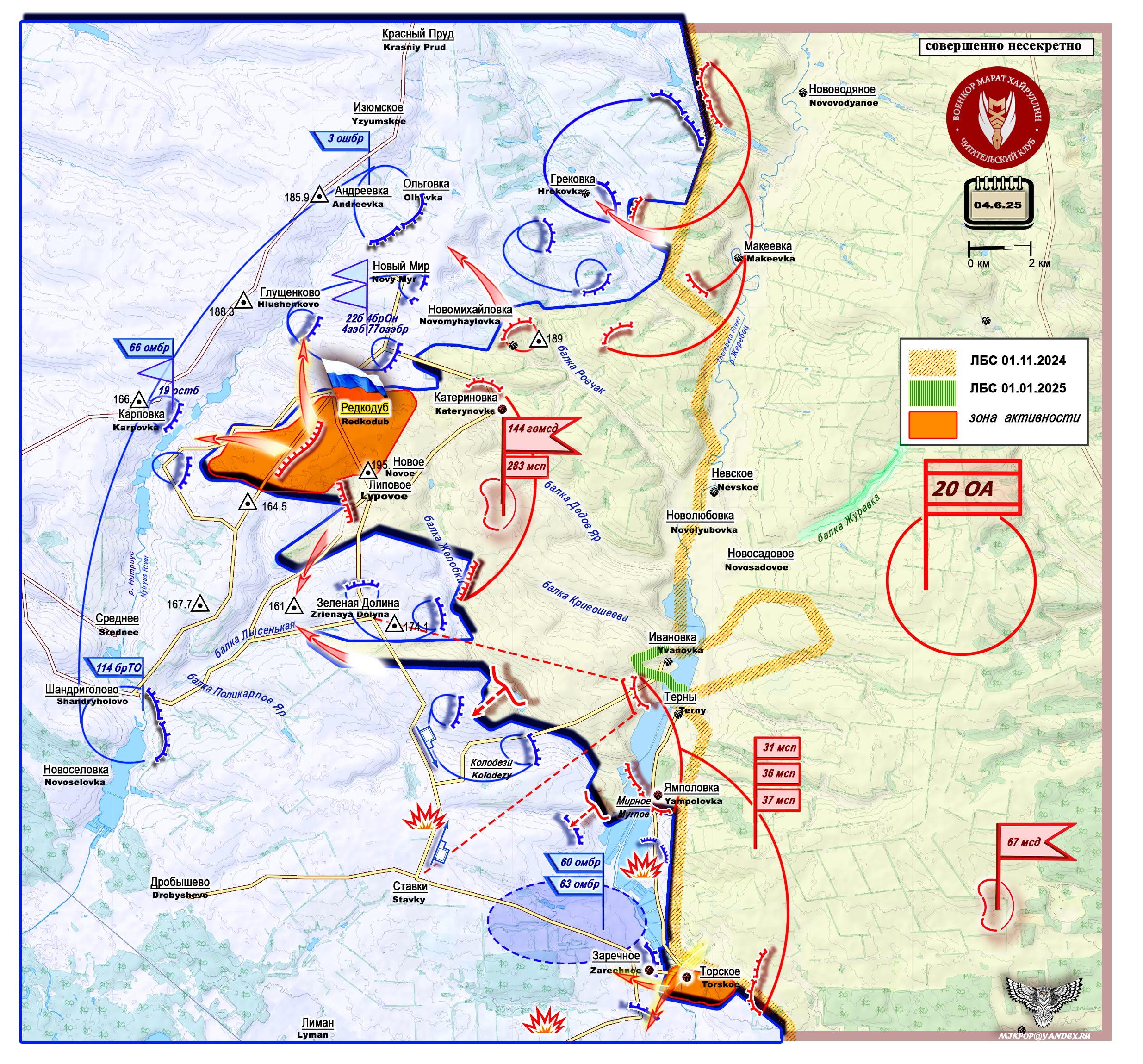
Throughout the second half of May 2025, our attention was focused on the central and southern sectors of the Donetsk direction. However, we anticipated that the enemy would be forced to redeploy some of its forces from "quieter" sectors to address critical situations in active areas. As soon as this regrouping was completed, our command began applying pressure to the sectors where Armed Forces of Ukraine units had been withdrawn. This is precisely what happened.
Activity has intensified in the Kursk and Volchansk directions of the buffer zone, as well as in the northern sector of the Donetsk direction near Makeevka-Torskoe. Persistent offensive operations continue on the right flank of the Pokrovsk sector and in the Dzerzhinsk (Toretsk) sector. The Chasov Yar sector is also heating up.
The Makeevka-Torske area, which includes the village of Redkodub, is situated on the watershed heights between the Nitrius River (west) and the Zherebets River (east). (The text is a bit hard to read, but you can see the label for the Nitrius/Nytryus River between Srednee and Karpovka. The Zherebets is basically along the yellow line of combat contact line for November.) The terrain is sharply uneven, with numerous lowlands, tributary streams, and gullies. By liberating Redkodub, Russian Armed Forces units have secured the commanding heights (ridge) of the watershed.
The village of Redkodub had around 500 residents. It was under Russian control from May 2022 until September 2022, when our units withdrew. In late April, after the liberation of the settlements of Novoe and Katerinovka, a wedge was driven into the AFU’s defenses in this area. Currently, efforts are underway to expand this wedge.
Following the liberation of Redkodub, Russian forward units have reached the left bank of the Nitrius River near the settlement of Karpovka. Through flanking attacks toward Olgovka and Grekovka (right flank, spelled “Olhovka” and “Hrekovka” on the map) and Height 161.0 (west of Zelenaya Dolina, with a northern envelopment), they are expanding the bridgehead. The Olgovka-Karpovka-Shandrigolovo (spelled “Shandryholovo” on the map) line represents the AFU’s last defensive belt before reaching the Oskol watershed, cutting off crossings over the Nitrius River, and isolating the southern part of the Kupyansk direction from the center. (This line is the blue line on the far west part of the map.)
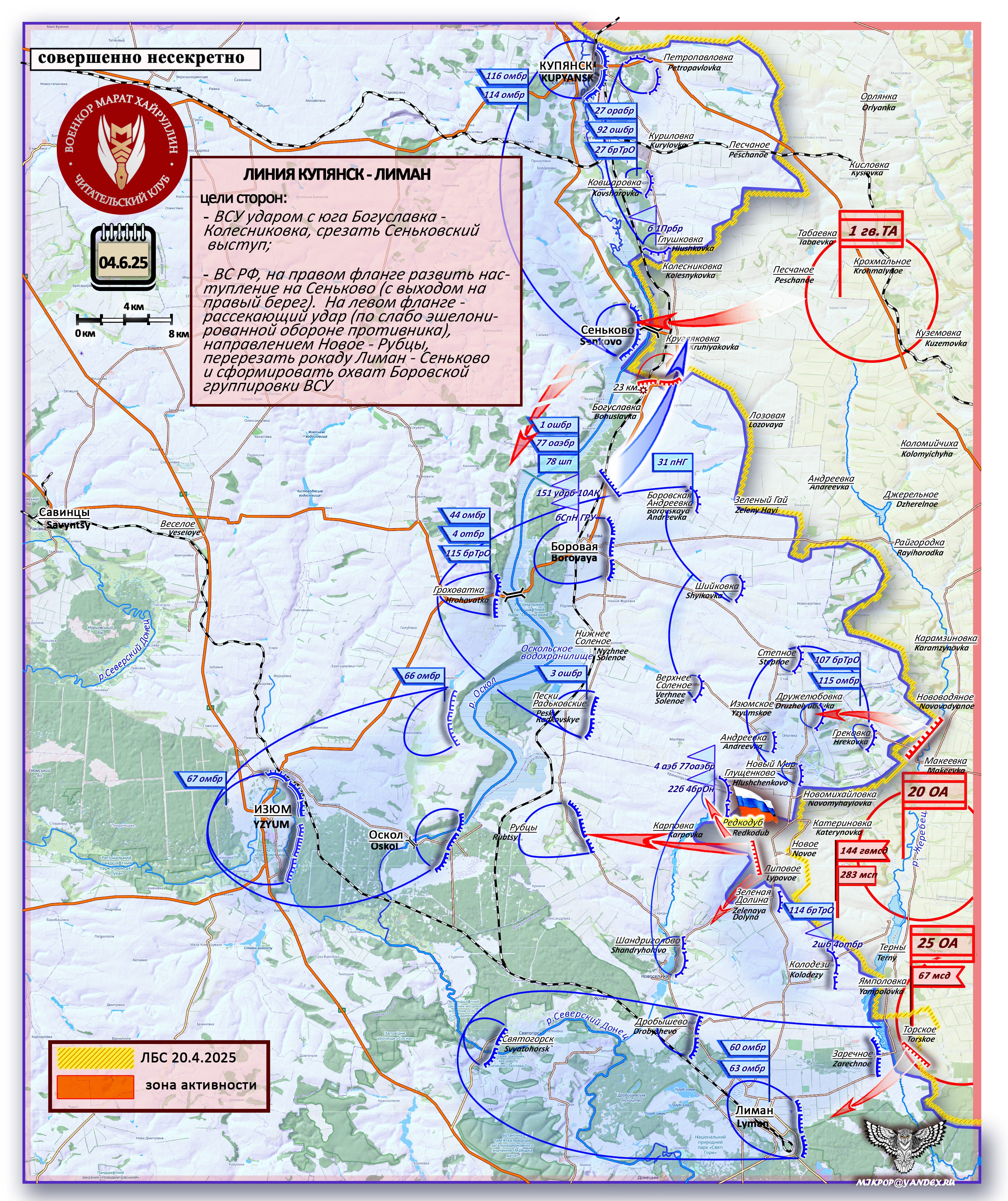
Top text box of the above image:
KUPYANSK - LIMAN LINE
Goals of the parties:
- The AFU must make an attack from the south Boguslavka - Kolesnikovka, cut off the Senkovo salient (on the map "Boguslavka is spelled "Bohuslavka" and "Kolesnikovka" is "Kolesnykovka," look for the big blue arrow*).
-The Russian Armed Forces, on the right flank, may develop an offensive on Senkovo (with an exit to the right bank; look for the big red arrow on the northern part of the map*). On the left flank, they will make a cutting attack (on the weakly echeloned defense of the enemy), in the direction of Novoye - Rubtsy (the big red arrow from Redkodub*), cut off the Liman - Senkovo rocade, and form an envelopment of the Borovaya group of the Ukrainian Armed Forces.
My job laid me off today.
I hear the Russian army is hiring, what if I could actually escape from jail America and go fight for Russia, or drive logistics at least....
Thanks 👍